Central Thailand · City
Bangkok
Bangkok is Thailand’s capital and largest city, on the low Chao Phraya River delta in central Thailand. It has been the royal capital since 1782, when King Rama I founded Rattanakosin on the river’s east bank, and it remains the country’s main international gateway.
Overview
Overview
Bangkok is Thailand’s capital and largest city, on the low Chao Phraya River delta in central Thailand. It has been the royal capital since 1782, when King Rama I founded Rattanakosin on the river’s east bank, and it remains the country’s main international gateway.
Bangkok has two international airports (Suvarnabhumi and Don Mueang); road traffic is often heavy, and rail and river routes are commonly used where congestion is severe.
Stay
Where to stay
See how the main places to stay differ in location, atmosphere and getting around.
Sukhumvit
A long BTS-served hotel and dining corridor, denser after dark than the old city.
Silom–Sathorn
A more compact financial-and-riverside base with Skytrain and metro through the district.
Rattanakosin / old city
Heritage walks around the Grand Palace and Wat Pho, with less Skytrain coverage than Sukhumvit or Silom.
Experience
What it's like
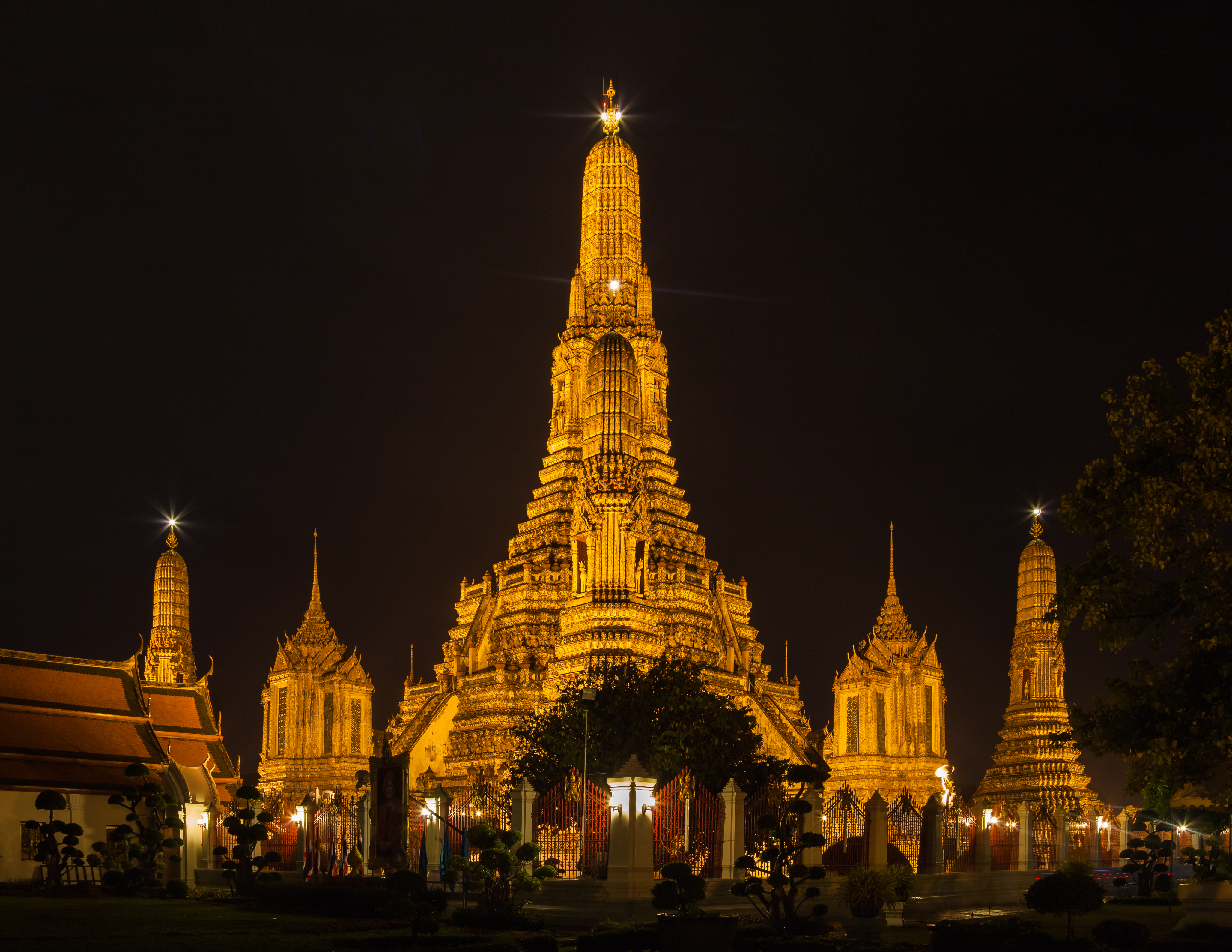
The historic core sits on Rattanakosin Island, where the Grand Palace and major Buddhist temples concentrate along the Chao Phraya River. East of the old walls, the city expands into shopping hubs around Siam and Ratchaprasong, financial streets along Silom and Sathon, and the long Sukhumvit corridor of hotels and services. West of the river, Thonburi retains canals and lower-rise neighbourhoods, including Wat Arun. Elevated and underground rail lines, river express boats, and buses connect a sprawling metropolis that guide sources describe as still marked by heavy road traffic alongside a mix of street markets and malls.
Areas to know
These are reference descriptions of areas within Bangkok — not a stay comparison.
- Rattanakosin (Old Bangkok) — Grand Palace, Wat Pho, and a dense temple belt along the river.
- Khao San / Banglamphu — Budget-traveler services north of the historic core.
- Yaowarat & Phahurat — Chinatown and nearby Indian commercial streets; markets, shrines, street food.
- Siam Square / Ratchaprasong — Central shopping district and a major Skytrain interchange.
- Silom / Sathon — Office towers and evening entertainment districts.
- Sukhumvit — Long east–southeast corridor of hotels, restaurants, and BTS stations.
- Dusit — Broad avenues, palace grounds, and national institutions.
- Thonburi — Wat Arun, canals, and lower-rise urban fabric than the eastern commercial belts.
History and sights
Bangkok grew from an Ayutthaya-era river settlement into the Thonburi capital, then Rattanakosin from 1782 under King Rama I. Major documented sites include Wat Phra Kaew / the Grand Palace, Wat Pho, Wat Arun, the Golden Mount, Wat Traimit, the National Museum, and Jim Thompson House. Street food is widespread; Yaowarat and Phahurat are established food and market districts, and retail ranges from markets like Chatuchak Weekend Market to large malls.
Things to do
- Royal and Buddhist sites — Grand Palace, Wat Pho, Wat Arun, Golden Mount, Wat Traimit
- River and canal trips — Chao Phraya Express boats and Thonburi canal routes
- Markets and shopping — Chatuchak Weekend Market, Yaowarat street food, Siam-area malls
- Museums and historic houses — National Museum, Jim Thompson House
- Regional day relationships — Ayutthaya upriver; Nonthaburi / Ko Kret and Samut Prakan within the metro area
Plan your visit
Plan your visit
When to go
Bangkok is warm to hot year-round. A relatively cooler, drier period is commonly described around November–February; March–April is typically the hottest stretch, and the wetter southwest-monsoon season runs roughly May–October.
Getting there & around
Getting there
Suvarnabhumi Airport (BKK) is east of the city; Don Mueang (DMK) is north. Intercity rail uses Krung Thep Aphiwat Central Terminal, with Hua Lamphong still relevant for some services. Long-distance coaches use the Mo Chit, Ekkamai, and Sai Tai Mai terminals.
Getting around
Common transport modes described by reference sources include the BTS Skytrain, MRT, Airport Rail Link / SRT services, Chao Phraya Express boats, Saen Saep canal boats, buses, metered taxis, tuk-tuks, motorbike taxis, and rideshare apps. Rail and river routes are commonly used where road congestion is severe.
Information used
Information used
Reference information — Wikipedia · Wikivoyage · Tourism Authority of Thailand · Wikidata — ordinary geography, place identity, historical context, and broadly established characteristics.
Wherely research — W3-EPIC-012 L3 Decision-Depth Promotion Wave 1 V1 — airport-arrival, local-movement, and day-trip decision guidance under Plan's practical-guidance disclosure, sourced from the repaired Place Depth Factory 20x80 R2 run (independently reviewed `PASS`; unit IDs BKK-U2/BKK-U3/BKK-U4). Wherely's governed stay-area comparison — the area distinctions and tradeoff cues in Stay are Wherely's synthesis of approved area evidence. Wherely also adds a small amount of additional governed guidance in Stay and/or Plan your visit where it offers a genuinely distinct point beyond what is already shown.
Photo credit
Hero photograph: Wat Arun , a temple situated in the city of Bangkok by Diego Delso, licensed under CC BY-SA 3.0.
What to do next
What to do next
Return to Central Thailand when you want the wider geography, or save this Place when it still fits.